27 Aralık 2012 Perşembe

DRACO... Winter Storm Moves East.. ... White Christmas..The Movie..

To contact us Click HERE
snow
It's snowing somewhere... even if not here...

DRACO is moving East and bringing wintry weather with it to areas who have not yet seen winter this year. Iowa is going to be covered in snow.


Travel will be affected. There will be travel delays.

Already Southwest Air has posted Travel Advisories for multiple airports.


  • Chicago (Midway) (MDW)
  • Denver (DEN)
  • Des Moines (DSM)
  • Kansas City (MCI)
  • Milwaukee (MKE)
  • Omaha (OMA)
Can you say MIDWEST WINTER STORM???
If you are a kid you are thrilled. If you are a parent you are uttering long sighs and muffling curse words under your breath as Winter is making a statement and there will be more named storms down the road after DRACO takes off for Pittsburgh and West Virginia.
If you are down in the white territory... you are NOT having a White Christmas. Sorry Charlie Brown.
This is as close as I get to a white Christmas... 

Yup, if this post is disjointed it's because I am watching this movie on an old TV even though I own a copy and it's probably downloaded somewhere here. I feel younger, like a little girl watching the Wizard of OZ once a year or watching it with my best friend at 16 and trying to learn the dance steps and write down the words to Sisters... the way we did back when you couldn't stop and start the video.  Can you believe a boy taped the words on an old tape recorder at 2am on Channel 6 in Miami and then sat stopping and starting it to get the exact words for us... Thank you Joe.
So.............my Christmas is going to be as warm as Vermont was before it snowed magically in the movie. Unless there is a Christmas miracle for a Jewish girl who is still waiting for her Chanukah present. 
God I love this movie..................................
Back to the weather............... (but this movie is about the weather... because... without snow you can't get people to go to Vermont to go skiing... you know???)
So as this system slices across the country it is creating severe weather tonight and there is possible rotation in Missouri. No..I do not mean Vera Ellen spinning while doing a tap dance..


It's a slim line but it's a strong one... as the warm, warm air below meets the cold, cold air rushing in as nature hates a vacuum. 

So.... there goes DRACO. 
http://www.npr.org/blogs/thetwo-way/2012/12/19/167617464/a-winter-storm-is-pummeling-the-rockies-and-the-plains-are-next
The press is all over it. 
http://fox8.com/2012/12/19/seasons-first-blizzard-warning-for-midwest/
Then again the Russia press is covering the coldest winter they have had in decades.
http://rt.com/news/russia-freeze-cold-temperature-379/
If there is a tornado... Reed is on it!
Watch the weather warning he has posted below:
http://www.youtube.com/watch?v=enYvkL-lbEw&feature=youtu.be
This is what you will see... he has people on the ground in Omaha dealing with Thundersnow!Watch... it's good... if you like weather and if you don't like weather...why are you here on my blog?

As for me... I'm in White Christmas heaven as they are playing it over and over :)
DRACO moving East. Stay on top of it if it's moving your way?
And.... I have a question here? NASA has released a set of answers to questions people have been calling them concerning the possible end of the world in less than 2 days. My question is... WHY WOULD ANYONE CALL NASA??
I mean if you thought the world was going to end...who would you really call?? 
NASA?? I mean... I love them ..but they lied to us about two space shuttle crashes saying that the crew was vaporized and didn't suffer ..twice... until we found out they weren't vaporized... 
I do love NASA but... call them? And, where do you find the NASA Hotline I wonder?
If it was weather involved I'm sure I'd call Bryan Norcross... 
The Pope? He's online now you know...
The White House?
Drudge... imagine if we flood his request box with questions he'd answer them somehow.. find a phone booth to jump into and fly off to save the world maybe.. 
Come on...who is calling NASA? I want to know... 
If you want to go to their website.... there are a list of answers to questions you never thought to ask:
http://www.nasa.gov/topics/earth/features/2012.html#polar

Below, NASA Scientists answer questions on the following 2012 topics:
  • End of the World
  • 'Prediction' Origins
  • Mayan Calendar
  • Total Blackout
  • Planetary Alignment
  • Nibiru/Planet X/Eris
  • Polar Shift
  • Meteor Strike
  • NASA Science
  • Solar Storms

And....there you have it.
That's my take on Draco... White Christmas (the movie.... teaches you history, weather and romance) and ............................ my birthday's coming so maybe I can wish for snow on my birthday if it's not happening sooner... later rather than sooner??
Some great links on www.spaghettiweather.com so go play on the weather playground and I'm going to go watch Danny Kaye dance with Vera Ellen and pretend I am fifteen again if just for another hour or two. 
Sweet White Christmas Dreams,
BobbiStorm
Ps if you'd rather listen to Jimmy Buffett.. enjoy 
http://www.youtube.com/watch?v=GCDWt7aVMVI
I have that somewhere ... a gift from "stalker friend" back when he was sending me cassettes before we moved forward to CDs...  scary if you think on it too much... but I don't think on it too much. Linda told me not to think too much when not in her presence...so that's my excuse and I'm sticking to it!! 
Christmas Island
(why does Jimmy look like Bing and why is he sitting in a big sushi boat? hmmmmnnnn)

    Snow, Rain, Tornadoes.. DRACO is leaving a legacy

    To contact us Click HERE


    This is a classic Tornado signature that screams severe weather in the south as snow and cold rain plaque Chicago and Milwaukee.


    Compare the current, but changing loop above with the image below of the storm as it was headed towards Alabama bringing Twisters their way.
    Here's a local news channel doing coverage that you can watch online:
    http://www.fox10tv.com/generic/video/LiveStream_FOX10
    Up in Iowa there's snow...  seems the place to go if you want to see snow today.
    http://www.cnn.com/2012/12/20/us/midwest-blizzard/
    Down below the Mason Dixie Line are severe, violent storms.


    Breaking News ‏@BreakingNewsDamage reports in Mobile concentrated on West and Northwest sides of city between I-65 and I-165 - @weatherchannel bit.ly/VToYvF View tweet 
    •  Reply 
    •  Retweet 
    •  Favorite


    Early, predawn tornadoes are the worst kind as there is little early warning without an alarm sounding in town or on a weather radio. They go under the radar while we sleep..


    Pictures will come in all day long as the sun comes up... 
    http://www.usatoday.com/story/news/nation/2012/12/20/storm-tornado-mobile-alabama/1781677/
    As this moves east into Alabama and the panhandle of Florida there are multiple weather threats.

    Tornado Watch

    TORNADO WATCH OUTLINE UPDATE FOR WT 689
    NWS STORM PREDICTION CENTER NORMAN OK
    425 AM CST THU DEC 20 2012

    TORNADO WATCH 689 IS IN EFFECT UNTIL 1200 PM CST FOR THE
    FOLLOWING LOCATIONS

    FLC033-091-113-201800-
    /O.NEW.KWNS.TO.A.0689.121220T1025Z-121220T1800Z/

    FL
    . FLORIDA COUNTIES INCLUDED ARE

    ESCAMBIA OKALOOSA SANTA ROSA
    $$


    Fire Weather Watch

    URGENT - FIRE WEATHER MESSAGE
    NATIONAL WEATHER SERVICE MOBILE AL
    632 AM CST THU DEC 20 2012

    ...FIRE WEATHER WATCH IN EFFECT FROM LATE FRIDAY MORNING THROUGH
    FRIDAY AFTERNOON FOR THE WESTERN FLORIDA PANHANDLE DUE TO A
    PERIOD OF CRITICALLY LOW RELATIVE HUMIDITY AND HIGH 20 FOOT WIND
    SPEEDS...

    .MUCH DRIER AND COOLER AIR WILL FILTER INTO THE REGION THROUGH
    FRIDAY IN THE WAKE OF A STRONG COLD FRONT. HUMIDITY VALUES WILL
    DROP INTO THE MID 20 PERCENT RANGE ACROSS THE WESTERN FLORIDA
    PANHANDLE FRIDAY AFTERNOON WITH 20 FOOT WINDS SPEEDS NEARING
    15 MPH.

    These storms are moving fast... forward speed wise .... if you know anyone in their path give them a text and make sure they are aware as people are busy getting ready for vacations and watching other news stories. Not everyone is watching "Draco"

    Up in the north.. there are already travel delays at O'Hare....

    Stay tuned and hope all your relatives are flying west to east with non-stop flights...

    Besos Bobbi

    Strong Southern Winter Storm on Christmas Day

    To contact us Click HERE

    With memories of the 1969 historic tornado outbreak... weather forecasters are carefully trying to predict where and when the worst of this storm will hit. The problem is.. weather like this is fluid and not a Cat 2 Hurricane which is easier to predict.  A lot depends on the timing, heating of the day, contrast between the cold air to the north of it and the warm air to the south and sometimes storms like this feed on their own energy.  Being off by a few hours can mean the difference of disaster in some small Southern hamlet or a wicked hour of weather by the front swings through with strong straight line winds.


    The weather passing through the South today is NOT the storm.

    The storm is back there and hasn't yet pulled itself together, but it will and it will take off fast once it does.

    Tomorrow:


    Christmas Day this system creates travel problems for I-10.  Houston Eastbound is a mess.

    The day after Christmas aka Wednesday takes the mess to I-95 and across most of the South.
    Severe weather could pop up anywhere and everywhere... 

    Thursday it is GONE.. POOF... gone hunting up north moving up the coast.
    1969's Historic Christmas Outbreak of Tornadoes... hoping this does not happen again...........and in our case the threat is further into the Carolinas this year...

    Compare the map for this coming storm and you will see why so many forecasters are worried.

    Look familiar?
    Stay tuned and pay attention to your local weather or your favorite weather site online.
    www.spaghettimodels.com has a few sites to pay attention to..
    http://www.nws.noaa.gov/largemap.php
    This image displays watches, warnings, statements and advisories issued by the National Weather Service
    http://www.newjerseyweather.com/weather/contours/640x480_wx_us_wx_msg1_i12_pattern.jpg(shows where it will snow or rain... site on the top of this blog, great site)
    http://www.spc.noaa.gov/products/outlook/day1otlk_1300.gif
    And look on the bottom right and choose your city of interest:
    You'll screen will look like this but with your city there...


    Lastly.. this storm like baseball is a work in progress. Until you see what any pitcher's got on any given day it's hard to say how he is throwing and hard to say who is hot when it comes to hitting home runs.
    Weather like sports is fluid.. so check back soon and I'll be on top of it.
    I'd love snow.. it's not in the forecast but I'd still love it!
    Besos BobbiStorm

    Forecasting Euclid the Elephant aka Christmas Storm Like the 7 Blind Men Story

    To contact us Click HERE


    It's hard to get a feel for this storm while watching the weather as every weather person and source seems to be forecasting a different part of the storm.

    It's one storm....sort of like the infamous Elephant.

    There are many components and many areas to watch for possible problems.

    It's a 3 ring circus or possibly a 2 ring circus with another ring opening for a midnight showing.

    There are multiple cities which will have different sorts of weather and several highways that will be affected!

    http://www.wordfocus.com/word-act-blindmen.html <--- elephant="elephant" link="link" olde="olde" p="p" story="story" to="to" ye="ye">


    Euclid the Elephant has several areas to watch as a hole it is bigger than it's parts.

    And, are you worried where Twisters might hit in the middle of the night or... are you worried where you may suffer accidents and troubled travel going home after Christmas dinner?
    Do you want snow or are you worried on freezing rain or icing on bridges at night as you travel home? Twisters in the south?
    Hail hitting your new Lexus or Mustang that you got as a Christmas present from Santa?
    Possible power outages from straight line winds just as you go to put away the leftovers in the freezer?
    Midnight tornadoes in Northern Alabama?
    Severe storms in Columbia SC or Fayetteville NC?
    Take your pic?

    But, if you are worried on twisters in Montgomery Alabama and they are covering snow in Oklahoma City and possible storms in New Orleans when you turn on TWC you are going to miss the story you need to know the most about.

    And, if you think the storm known as Euclid the Elephant is a Christmas Day event... you are right and you are wrong as it's also a Wednesday event in the South as it moves out of the Deep Coastal South and moves North... up the coast Thursday.

    If there was one storm to name so far this winter... it IS this storm, however had TWC not christened it with the odd name of Euclid.. it would still have been known as the Christmas Day Storm of 2012!

    So, I'm going to break this down like Caleb Weatherbee might in Ye Olde Almanac.. but I am not going to to do it in zones as much as along Interstates as that gives you the information you will most likely need as you travel home from where ever  you might have gone to spend Christmas.


    This is the Southern Part of the storm that most weather people are worried will be affected by possible twisters and other types of severe weather... hail, lightning, terrible driving weather.


    The area from Houston east to Jacksonville all needs to watch out.

    This can be seen in one of my favorite images... the red is where it will be most severe:


    Note ALL of Alabama is in Red.. as is Louisiana. Even if you drive safe, you could easily get caught in a bad traffic jam as an accident up the road is cleared away. Good luck... or stay another day if you can..

    Note the storm is winding up ...up near the I-20 in Oklahoma and Arkansas:


    There is a currently a line crossing through East Texas that has tornadoes possibly embedded and several cities currently have a tornado watch and there are even a few tornado warnings out there.

    Houston/Trinity/Polk all have Tornado Warnings. Good site:
    http://www.texasstormchasers.com/

    No one does Nola like Nola.com..
    http://www.nola.com/weather/index.ssf/2012/12/tornado_watch_until_1_pm_for_m.html#incart_river_default

    tornado watch wms_iNWS (2).png

    So...Houston, Lake Charles, New Orleans... eastbound and down all the way through Mobile and ALL of Alabama into the Panhandle of Florida... be careful.

    www.weather.gov

    Put in your Zipcode and see what your weather of the day is.. if there it's been colored in.. pay close attention!

    Will look a lot like this:


    Moving up towards I-20.. Shreveport is in the thick of it.


    Possible rotation and hail there ... 
    Possible tornado has touched down.. reports coming in...
    Also, College Station watch out this morning.
    I think I-20 could see the worst of it even though everyone is watching I-10.
    Perhaps the more sexy cities like Nola are more fun to cover on TV and catch our attention?
    Then again ... Dallas always gets attention and Dallas will get weather as the storm moves East.

    In the Atlanta Metro Area there are multiple problems.
    Rain, Possible Tornadoes and something few are mentioning... FOG in the evening. As most people drive home in the evening ... that's a feature that is getting lost in the shuffle as we look for twisters.
    THIS HAZARDOUS WEATHER OUTLOOK IS FOR NORTH AND CENTRAL GEORGIA.

    .DAY ONE...TODAY AND TONIGHT...

    ...WIDESPREAD DENSE FOG THIS MORNING...
    ...SEVERE THUNDERSTORMS LIKELY FOR PORTIONS OF WEST AN SOUTH TONIGHT...

    WEATHER HAZARDS EXPECTED...

    RESIDUAL MOISTURE FROM EARLIER RAIN WILL LEAD TO THE FORMATION OF
    WIDESPREAD DENSE FOG TONIGHT. MOTORISTS ARE URGED TO USE EXTREME
    CAUTION. REFER TO THE LATEST DENSE FOG ADVISORY.


    ISOLATED TORNADOES...DAMAGING WINDS...AND LARGE HAIL TONIGHT.


    Next...
    Augusta, GA... more of the same as it moves towards the coast...


    THERE IS A SLIGHT RISK OF SEVERE THUNDERSTORMS LATE TONIGHT MAINLY
    IN THE CSRA. DAMAGING WINDS ARE THE MAIN THREAT. A FEW TORNADOES
    ARE ALSO POSSIBLE.

    .DAYS TWO THROUGH SEVEN...WEDNESDAY THROUGH MONDAY.

    THERE IS A SLIGHT RISK OF SEVERE THUNDERSTORMS WEDNESDAY ACROSS
    THE REGION. DAMAGING WINDS ARE THE MAIN THREAT. A FEW TORNADOES
    ARE ALSO POSSIBLE.


    Columbia, South Carolina...


    • TonightRain, mainly after 9pm. Low around 54. East wind 6 to 11 mph. Chance of precipitation is 90%. New rainfall amounts between a quarter and half of an inch possible.
    • WednesdayShowers and possibly a thunderstorm, mainly before 5pm, then a chance of showers and thunderstorms after 5pm. High near 64. Breezy, with a south wind 16 to 25 mph, with gusts as high as 43 mph. Chance of precipitation is 100%. New rainfall amounts between a half and three quarters of an inch possible.


    Note the whole area from I-10 to I-20 is a mess...


    Off the grid I am covering for areas in my region... is the geographic area that correlates with the New Madrid Fault... it's a mess and a strong warning has been put out for this region...


    Choose a city... any city in that area and take it VERY seriously..some areas here rarely get blizzard warnings. This is NOT Postville, IA... it's south of the normal snowstorm warning areas.


    Thems a lot of warnins' there...take em real serious. No joke...

    Memphis... you're in it and in it big time.

    Moving north from I-10 the whole area on Wednesday is horrible.

    Mind you if you are out near College Station, Houston, Lake Charles, Montgomery..stay put today, travel tomorrow. If you are anywhere from Savannah to Baltimore, travel sooner rather than later as tomorrow and late tonight will be sketchy at best.


    The best you get is 60% chances of rain in the south...
    90 and 100% from Rocky Mount, NC all the way to Trenton, NJslow going, multiple accidents at best.. and could be much worse.
    Snow begins around Delaware (this could change) and continues north.
    Southwest Air...Travel Warnings
    http://www.southwest.com/html/advisories/swa_travel_advisory_201211241356362490489.html
    If you were planning on flying out of or into these airports...check with your carrier!
    • Akron-Canton (CAK)
    • Buffalo/Niagara (BUF)
    • Cleveland (CLE)
    • Detroit (DTW)
    • Indianapolis (IND)
    • Oklahoma City (OKC)
    • Pittsburgh (PIT)
    • Tulsa (TUL)

    http://www.dallasnews.com/business/airlines/20121221-midwest-blizzard-leads-to-some-american-airlines-southwest-airlines-flight-cancellations.ece
    More updates to follow.... 
    Storm still developing... stay informed...
    Besos for Now..
    BobbiStorm


    PDS - Particular Dangerous Situation .. Twisters in the Night

    To contact us Click HERE


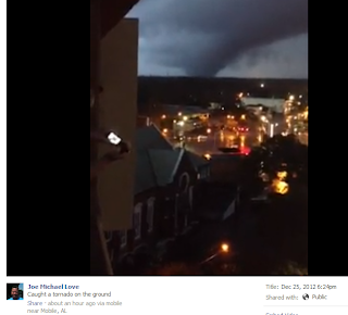
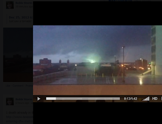
    The Mobile Tornado has everyone talking. Not that often you have a wedge shaped tornado on the ground for a long time in a metropolitan city on Christmas Day.

    I took a "print screen" photo of the Mobile tornado from WALA's towercam a few minutes ago. Large one...

    Amazingly this was the second tornado to touchdown in Mobile in less than a week.

    Texas also had tornadoes today as the first victim of this storm system died. A 25 year old man in a Houston suburb was killed when a tree fell on his pick up truck that he was riding this morning in Harris County.

    http://www.chron.com/news/texas/article/Nasty-storms-blamed-1-death-make-travel-tough-4144131.php

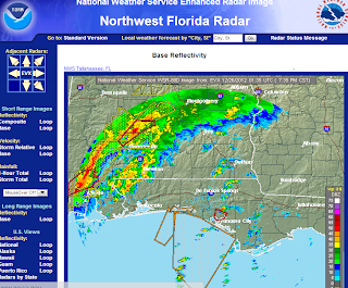
    Current Radar

    Notice the rain falling in South Carolina from the warm front that is associated with this system.

    Note the freezing conditions in Arkansas.

    The line of storms pushing through as warm, moist air is punching up into the heart of the cold weather creating dry lines, rotation and a memorable weather event on Christmas Day of 2012!

    Live updates are being forecast from Accuweather:

    http://www.accuweather.com/en/weather-video/video-arkansas-blizzard-conditions/655578741001

    Several people caught the Mobile Tornado on their cell phones...

    https://www.facebook.com/photo.php?v=4140595600830

    You ABSOLUTELY must watch this video... real video with a real tornado not special effects.


    Another great video from the same storm on Facebook:

    https://www.facebook.com/photo.php?v=10200265647749842&set=vb.1412645710&type=2&theater


    The power going out..flashes on air live... over 20,000 people without power in Mobile.

    Ice Storm Warnings are up for parts of Virginia ...
    http://woay.com/Alerts.aspx?aid=259
    URGENT - WINTER WEATHER MESSAGE
    NATIONAL WEATHER SERVICE CHARLESTON WV
    419 AM EST TUE DEC 25 2012

    ...POTENTIAL FOR HEAVY ICE ACCUMULATIONS WEDNESDAY...

    .A STRONG LOW PRESSURE SYSTEM WILL MOVE FROM THE WESTERN GULF
    COAST NORTHEASTWARD...PASSING ACROSS OUR AREA LATER TUESDAY NIGHT
    AND WEDNESDAY. THIS WILL BRING A WINTRY MIX OF PRECIPITATION TO
    THE AREA...INCLUDING THE POTENTIAL FOR HEAVY ICE ACCUMULATIONS.

    WVZ046-047-251730-
    /O.UPG.KRLX.WS.A.0006.121226T0300Z-121227T1100Z/
    /O.NEW.KRLX.IS.W.0001.121226T0300Z-121227T0000Z/
    POCAHONTAS-RANDOLPH-
    INCLUDING THE CITIES OF...MARLINTON...ELKINS
    419 AM EST TUE DEC 25 2012


    Virginia into Maryland will see ICE accumulations from this system.

    There is damage being reported in Murphy High School in Mobile and the Field House is reportedly gone and minor damage throughout the campus.

    http://www.mhspanthers.com/


    Panama Beach has a tornado warning currently as the system moves east though as of yet to reports of tornado damage anywhere.

    When I said ALL of Alabama was under the gun this morning I was not exaggerating. 


    I think that picture above says it all...and it is moving East and North East..towards Georgia and the Carolinas.
    As I said earlier this morning... it's a tale of two and three and four storms... 
    Euclid the Elephant... pick a place and feel a different type of storm.


    Stay safe and if you are in the Carolinas... it's headed that way tomorrow... 
    Check them out...they cover the area well..
    Besos BobbiStorm... stay safe and stay informed. If you have a weather radio.. keep it on!


    20 Aralık 2012 Perşembe

    Big Thunder Hiatus at Disneyland

    To contact us Click HERE


    After January 6th, you'll have to wait a while to take a spin on the wildest ride in the wilderness at Disneyland, because Big Thunder Mountain will be receiving a full refurbishment that will last until Fall, 2013.

    The park will be giving the famous coaster some serious TLC, including all new ride track, ride vehicles, and a fresh coat of paint for the mountains themselves.  Replacing the track of the ride, which first opened in 1979, will help to bring the ride up to modern standards much like the park did with Space Mountain in 2005.  It stinks to have the ride closed for almost a year, but the renovation will allow the ride to operate for decades into the future.

    Disney does not regularly make announcements about ride manufacturers that are involved in projects like this, but it is said the the new coaster track will be provided by Dynamic Attractions, who built the track for Space Mountain, as well.


    Flying Scooters Headed to Michigan's Adventure

    To contact us Click HERE

    The Flying Scooters at Knoebels
    Michigan's Adventure made a pleasant announcement today regarding their new for 2013 ride, which will be a Larson Flying Scooters flat ride.  Highly regarded among ride fans, the Flying Scooters allows riders to control their ride vehicle using a large wing, and with enough practice guests can create a rather wild ride.

    The official name for the ride has not been announced yet, nor has the location in the park where it will be located.
    Michigan's Adventure will also celebrate the 25th anniversary of the Wolverine Wildcat roller coaster, and the 15th anniversary of the mighty Shivering Timbers in 2013.

    It is nice to see the Flying Scooters popping up at more parks lately, this is one of several already announced for next year.  The Great Escape, Knott's Berry Farm, and I believe Fun Spot will build them as well in 2013.

    Even more interesting to me is how late this announcement came after Cedar Fair's 'big' rides were revealed.  I had heard that Mr. Ouimet was taking a hard look at some of the plans for parks, and making some changes.  Perhaps this announcement is the result of one of those careful evaluations.  Or perhaps not, but it's a nice addition for the park either way!