It occurs to me while watching TWC as their reporters interview people in Highland, NJ that they never show maps. Okay, I'm a little over the top when it comes to geography but I do think people need to appreciate these things. The above is a very cute little Thai restaurant with great reviews online that was badly affected by Hurricane Sandy... trying to stay open.. trying to repair and continue what was like as normal.
I love maps.
I'm on record and have been for a long time.
But, to properly understand this you need to look closer.. and understand the details of the illusion of safety from a storm surge.
I'm quoting in brackets here from Wikipedia on Highland, NJ. There are other sources, obviously, but we all love to look at Wikipedia as we love to Google so it's easiest and most simplistic."Highlands is a borough in Monmouth County, New Jersey, United States. As of the 2010 United States Census, the borough population was 5,005,[7][8][9] reflecting a decline of 92 (-1.8%) from the 5,097 counted in the 2000 Census, which had in turn increased by 248 (+5.1%) from the 4,849 counted in the 1990 Census.[14] It is the home town of film maker, director, and comic book writer Kevin Smith. The eastern part of the town is built on a high bluff that overlooks Sandy Hook and the Atlantic Ocean. Atop this bluff are the Navesink Twin Lights.Highlands was incorporated as a borough by an act of the New Jersey Legislature on March 22, 1900, from portions of Middletown Township. Additional portions of Middletown Township were annexed in 1914.[15]Highlands is part of the Bayshore Regional Strategic Plan, an effort by nine municipalities in northern Monmouth County to reinvigorate the area's economy by emphasizing the traditional downtowns, dense residential neighborhoods, maritime history, and the natural beauty of the Raritan Bayshore coastline."
Navesink Lighthouse
Highlands, New Jersey
Still there is an illusion of safety when there is a barrier island in front of your town and you are "inland" on a HIGHland.
See the Barrier Island...

Note a lot of the areas that were devastated have names like "highlands" however as the crow flies they are not that far from the water and just off of Sandy Hook which I said days and days before landfall would take a direct hit of damage from wherever Sandy hit...
Go out farther:

The water came into Raritan Bay..that little inlet and had nowhere else to go and it climbed higher than anyone thought it would that did not live on that little thin barrier island to the East. Yes, the barrier island always gets slammed.. we know that. The lesson of Sandy, who carried huge, vast amounts of water and swollen swells and slammed it into that area and the water climbs higher than expected. First the barrier island goes and then the water filled with raging waves crosses the barrier island the takes what it can from the homes close enough to the water ... even when they are in theory "up higher" than the beach.
Example.. a true storm surge from a Category 4 or 5 in Miami coming in from the East and slamming into Miami Beach would wash a wall of water over Washington Avenue and Collins Avenue and the storm surge would travel across beautiful Biscayne Bay and deposit big boats and debris up onto Miami Shores in the same way that piano just showed up on the sandbar one morning. Except it won't be a teenage prank but Mother Nature in a really bad mood.
Here are some links to see what Sandy did to HIGHLAND NJ.. not just the barrier islands.
http://video.today.msnbc.msn.com/today/49682965/#49682965
http://middletown-nj.patch.com/articles/atlantic-highlands-prepares-for-the-road-ahead
http://www.nj.com/monmouth/index.ssf/2012/11/atlantic_highlands_restaurants_without_power_bring_their_menus_to_the_street.html
The water of Raritan Bay swirled around Sandy Hook or across Sandy Hook and then deposited itself onto Highland NJ from the north...
Note where the Thai Restaurant mentioned in that last link is:

The restaurant is or was where the A is on the map... I'm sure they felt they would get by safer than Coney Island to the North or Breezy Point to the North, but Sandy had that large fetch from the North to the South that I wrote about when I was at Wilmington Beach.. Wrightsville.. .it slammed that water onto the "heights" of Highland, NJ.http://www.urbanspoon.com/cities/53-north-jersey/restaurants/1510270-kunya-siam/menuThe point I am making here is this is a real place that felt some what safe, despite slosh charts for the worst case scenario.
If it happened before, it will happen again.
But, way back when there was no cute Thai restaurant there...
Something to think on if you think you have the illusion of safety where you live.
3 days from more bad weather......................
My son, by the way, got gas in Brooklyn... not sure how long he waited online so he's happy.. mostly so he can go vote and have the illusion of safety ..
We all have an illusion of safety... from weather, from bad things happening.. from terrorism.
Enjoy it.. it's an illusion.
Enjoy the good times.. prepare for the bad times and know that the worst case scenario does and will come true.. sometimes.

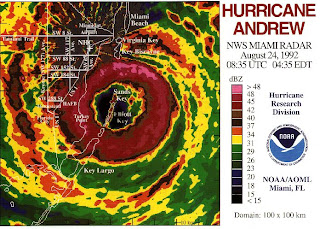
I posted this image on my Start of the 2012 Atlantic Hurricane Season..a look back
http://hurricaneharbor.blogspot.com/2012/06/june-1st-2012-day-1-hurricane-season.html
Besos Bobbi
More on the next storm later today...
Hiç yorum yok:
Yorum Gönder